


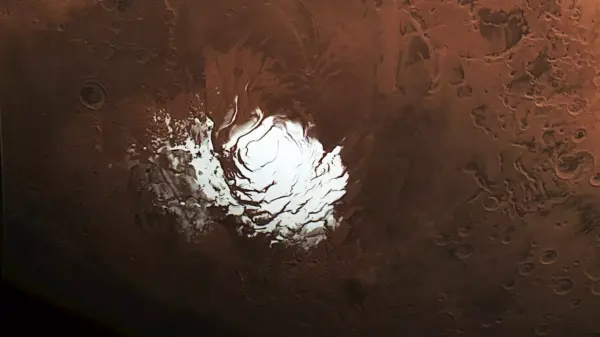


NASA’s Mars Reconnaissance Orbiter (MRO) has provided new insights into a long-standing mystery at Mars’ south pole, revealing that a region once thought to contain an underground lake is more likely a layer of rock and dust. This conclusion stems from a recent study utilizing an enhanced radar technique that allows for deeper sub-surface observations of the Martian terrain.
Significant Radar Discoveries
The MRO’s findings challenge earlier interpretations made by the European Space Agency’s Mars Express, which in 2018 detected a signal suggesting a subglacial lake beneath the ice cap. The new analysis, led by researchers Gareth Morgan and Than Putzig from the Planetary Science Institute, relied on a sophisticated maneuver that permitted the radar instrument to penetrate deeper into the Martian crust.
Utilizing a technique known as a “very large roll,” the MRO was maneuvered to rotate 120 degrees, significantly enhancing the radar’s ability to gather data from greater depths. On May 26, the MRO successfully captured radar signals from an area measuring approximately 12.5 miles wide, which is buried under nearly 1 mile of ice. This precise rolling technique was developed in collaboration with NASA’s Jet Propulsion Laboratory and Lockheed Martin Space.
Implications for Future Exploration
The initial hypothesis of a liquid water lake, which generated considerable scientific interest due to water’s potential link to life, has now been undermined. The radar’s faint signals suggest the presence of a solid layer of rock and dust instead. Morgan noted that despite nearly two decades of attempts to observe this area with the Shallow Radar (SHARAD) instrument, the recent maneuver finally provided clarity.
“This new data won’t settle the debate, but it makes it very hard to support the idea of a liquid water lake,” said Morgan.
The implications of these findings extend beyond this particular area. The same radar technique may be applied to other regions of Mars, such as the Medusae Fossae formation, where scientists speculate about the presence of ice deposits that could support future human exploration. Putzig emphasized the strategic importance of locating water resources near the Martian equator, where conditions are more hospitable for human activity.
The MRO has been orbiting Mars since 2006, continually contributing to our understanding of the planet. Its enhanced radar capabilities, particularly the SHARAD instrument provided by the Italian Space Agency, are crucial for mapping Martian geology and assessing subsurface resources.
This latest research exemplifies the ongoing collaboration between various space agencies and highlights the evolving nature of planetary exploration. As NASA continues to refine its techniques and technologies, the quest to uncover the secrets of Mars remains a top priority.