


NASA’s Mars Reconnaissance Orbiter (MRO) has utilized an advanced radar technique to reassess a significant feature beneath the Martian south polar ice cap, challenging earlier interpretations of subsurface conditions. The recent study, led by scientists Gareth Morgan and Than Putzig from the Planetary Science Institute, indicates that what was previously thought to be an underground lake is more likely a layer of rock and dust.
In March 2018, the European Space Agency’s Mars Express orbiter detected a signal interpreted as a potential underground lake in the area adjacent to Mars’ south polar ice cap. This discovery sparked considerable interest within the scientific community, as liquid water is crucial for understanding the potential for life beyond Earth. However, the latest findings from NASA’s MRO suggest a different reality.
Using a technique that involves a significant 120-degree roll of the spacecraft, the MRO’s Shallow Radar (SHARAD) was able to penetrate deeper beneath the ice, revealing a faint radar signal rather than the strong reflection typically associated with liquid water. This maneuver allowed scientists to gather clearer images of the subsurface, a task that had previously met with limited success.
Putzig noted, “We’ve been observing this area with SHARAD for almost 20 years without seeing anything from those depths.” The enhanced radar technique was developed in collaboration with the operations team at NASA’s Jet Propulsion Laboratory (JPL), ensuring the safety of the spacecraft while maximizing the effectiveness of the radar signals.
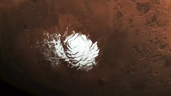
The target area spans approximately 12.5 miles and lies beneath nearly one mile of water ice. While the 2018 findings suggested a briny lake could exist—hypothesized to remain liquid due to high salt content—this new data complicates that narrative. The research highlights the need for further investigation into the Martian subsurface using advanced radar techniques, which could provide valuable information for future explorations.
The study’s conclusions also point to the possibility that the bright signal detected by Mars Express might simply be a smooth geological formation, such as an ancient lava flow. This hypothesis aligns with the observations made by the MRO, which indicated that the area below the ice is characterized by a topography of peaks and valleys.
Both Morgan and Putzig expressed enthusiasm for applying the large roll technique to other scientifically intriguing regions on Mars. One such location is Medusae Fossae, a vast geological formation at the Martian equator that has produced little radar return in past observations. Investigating this area could reveal potential water resources, essential for human exploration, as the equator is more hospitable compared to polar regions.
The Mars Reconnaissance Orbiter has been operational since 2006, providing extensive data that continues to refine our understanding of the Martian environment. The mission is part of NASA’s broader Mars Exploration Program, with JPL managing the orbiter and Lockheed Martin Space providing operational support. The SHARAD instrument was contributed by the Italian Space Agency, reflecting international collaboration in space exploration.
As scientists process this new information, they remain committed to unraveling the mysteries of Mars. The ongoing research not only enhances our knowledge of the Martian landscape but also lays the groundwork for future missions that may one day send humans to the Red Planet.