


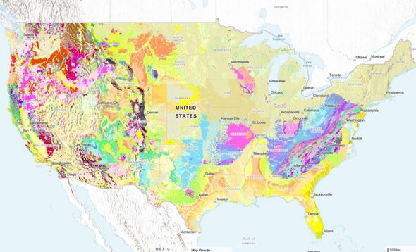
A recent initiative by the U.S. Geological Survey (USGS) has introduced a groundbreaking interactive map that illustrates the diverse rock formations beneath the surface of the United States. Unveiled in August 2023, this map represents three years of intensive research and collaboration among geologists, enhancing previous geoscientific mapping efforts spanning decades.
The new tool allows users to explore a wealth of information about the geological landscape. It organizes rock and sediment types into distinct units based on shared characteristics such as composition and age. This interactive feature enables users to search for specific geological properties or simply click on various areas of the map to access additional data and localized geological maps.
“This map provides complete, analysis-ready geologic data for the nation, in a format that is easy to expand going forward,” said Joseph Colgan, a research geologist at USGS and the leader of the mapping project. He emphasized that making this map available online aims to promote educational engagement and foster public appreciation for geology.
Innovative Mapping Techniques Enhance Efficiency
A significant advancement of this new mapping project is the development of a faster, primarily automated process for integrating geological data. This “solution” combines geologic maps from state geological surveys and the USGS, streamlining the mapping process considerably.
According to Sam Johnstone, another USGS research geologist involved in the project, this new method allows for the creation of national maps in a fraction of the time traditionally required. “Ongoing mapping efforts continually make new discoveries, but past national maps took decades to create, while our new method allows us to update our national map faster than ever possible before,” he said.
This initiative is part of a broader effort by the Association of American State Geologists and the National Geologic Map Database to standardize geological maps throughout the country, enhancing the availability and usability of geological data.
Applications and Future Collaboration
The interactive map serves a variety of purposes, appealing to both the general public and professionals in the field. Christopher Swezey, the USGS National Cooperative Geologic Mapping Program coordinator, highlighted the potential uses of geological maps, stating, “They can help experts look for energy, mineral, and water resources. They are also crucial for assessing earthquake risks and informing decisions about land use, infrastructure, and community planning.”
Despite its advancements, the map remains a work in progress. As noted by Eos.org, disparities in the availability and quality of geological data persist. For instance, the Idaho-Washington border presents a unique challenge, as differing information about the rock layers from each state has been reported.
“Such disparities are unavoidable on the new map,” Johnstone remarked. “The goal was to integrate data without altering the original maps’ interpretations. These disparities indicate opportunities for future collaboration among state agencies and with USGS.”
This innovative mapping tool not only enhances our understanding of the geological world beneath us but also opens the door to new discoveries and collaborative efforts aimed at improving geological data collection and application in the future.